Wildlife Tracking in Big Sur, California
Two of the Pacific Coast's most compelling wildlife spectacles happen at opposite ends of the year along the same stretch of water. Grey whales migrate south past Big Sur from December through February and return north from March through April — close enough to shore that the headland trails above the highway are legitimate whale watching platforms, no boat required.
Two of the Pacific Coast's most compelling wildlife spectacles happen at opposite ends of the year along the same stretch of water. Grey whales migrate south past Big Sur from December through February and return north from March through April — close enough to shore that the headland trails above the highway are legitimate whale watching platforms, no boat required. Sea otters are resident year-round in the kelp forests just offshore, visible from almost any coastal pullout with binoculars: floating on their backs, cracking urchins on their chests, entirely indifferent to the highway above them. The winter months — December through March — are when both species are most active and the coast is at its emptiest, which makes for wildlife watching without the summer crowds.
Weather & Conditions
| Month | High / Low | Rain Days | Conditions |
|---|---|---|---|
| Jan | 57° / 42°F | 12 | Peak |
| Feb | 59° / 43°F | 11 | Peak |
| Mar | 61° / 44°F | 10 | Peak |
| Apr | 63° / 46°F | 6 | Good |
| May | 65° / 48°F | 3 | Good |
| Jun | 67° / 51°F | 1 | Okay |
| Jul | 68° / 53°F | 0 | Okay |
| Aug | 69° / 54°F | 0 | Okay |
| Sep | 70° / 52°F | 1 | Okay |
| Oct | 67° / 49°F | 4 | Good |
| Nov | 62° / 45°F | 8 | Good |
| Dec | 58° / 42°F | 11 | Peak |
Where to Go
Last stop for supplies, gas, and reliable cell service before Highway 1 turns wild.
The most photographed bridge on the California coast. 260 feet above the canyon floor, 13 miles south of Carmel.
Volcanic rock rising from the ocean floor. Historic lighthouse, guided tours only.
Big Sur's largest state park. Coastal trail to the beach, redwood groves, and the Big Sur River mouth.
The closest thing to a town center. Nepenthe restaurant, the Henry Miller Library, and most lodges cluster here.
Purple sand from manganese garnet in the cliffs. Keyhole Arch rock formation. Unmarked turnoff on Sycamore Canyon Road — no cell service to find it.
Redwood canyon hiking, the Big Sur River gorge, and the main campground. 26 miles south of Carmel.
Cliffside luxury, no children under 18.
Hillside resort in the redwoods above the coast.
80-foot waterfall dropping directly onto a beach inside a sealed cove. The defining Big Sur image. Julia Pfeiffer Burns State Park, 37 miles south of Carmel.
Reached through a tunnel blasted into the cliff. Small protected cove, kelp forest snorkeling, and the most dramatic short hike on the coast.
Cliffside hot springs open to non-members overnight only. One of the strangest and most memorable experiences on the California coast.
Big Sur's longest sandy beach. The main surf break on the coast. 62 miles south of Carmel.
Four 19th-century lime kilns in a redwood canyon with a waterfall. One of the least visited and most rewarding stops on the coast.
No services. Full isolation. The point where Highway 1 feels genuinely remote.
Coastal bluff trails, tide pools, kelp forest diving, and grey whale watching from the headlands. 7 miles south of Carmel.
The only road crossing the Santa Lucia Mountains to the coast. Climbs to a ridge with views of both ocean and valley. Best stargazing access on the coast.
Know Before You Go
This is not a theoretical risk. Landslides, bridge failures, and rockfalls have closed Highway 1 for months at a time in recent years. Check Caltrans conditions the day before every drive and have a contingency plan. There is no alternate route.
From south of Carmel to north of San Simeon, reliable cell service is effectively absent. Download offline maps, notify someone of your itinerary, and do not rely on your phone for navigation or emergency contact.
June, July, and August are socked in with marine layer from late morning onward. If you visit in summer, plan for it: hike above the fog line, embrace the atmosphere, and do not expect a Mediterranean coastline.
Ready to plan your wildlife tracking window?
Tell us when and how you travel — we'll match it to the right months, the right properties, and the right price.
Hotels & Lodges for Wildlife Tracking
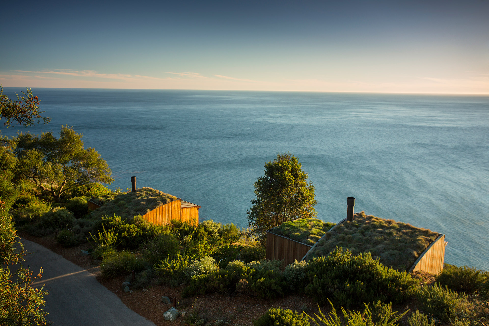
Post Ranch Inn
Perched directly on the 1,200-foot cliff edge, the Post Ranch is the definitive Big Sur address — no children, no compromises, and an unobstructed Pacific horizon from every room.
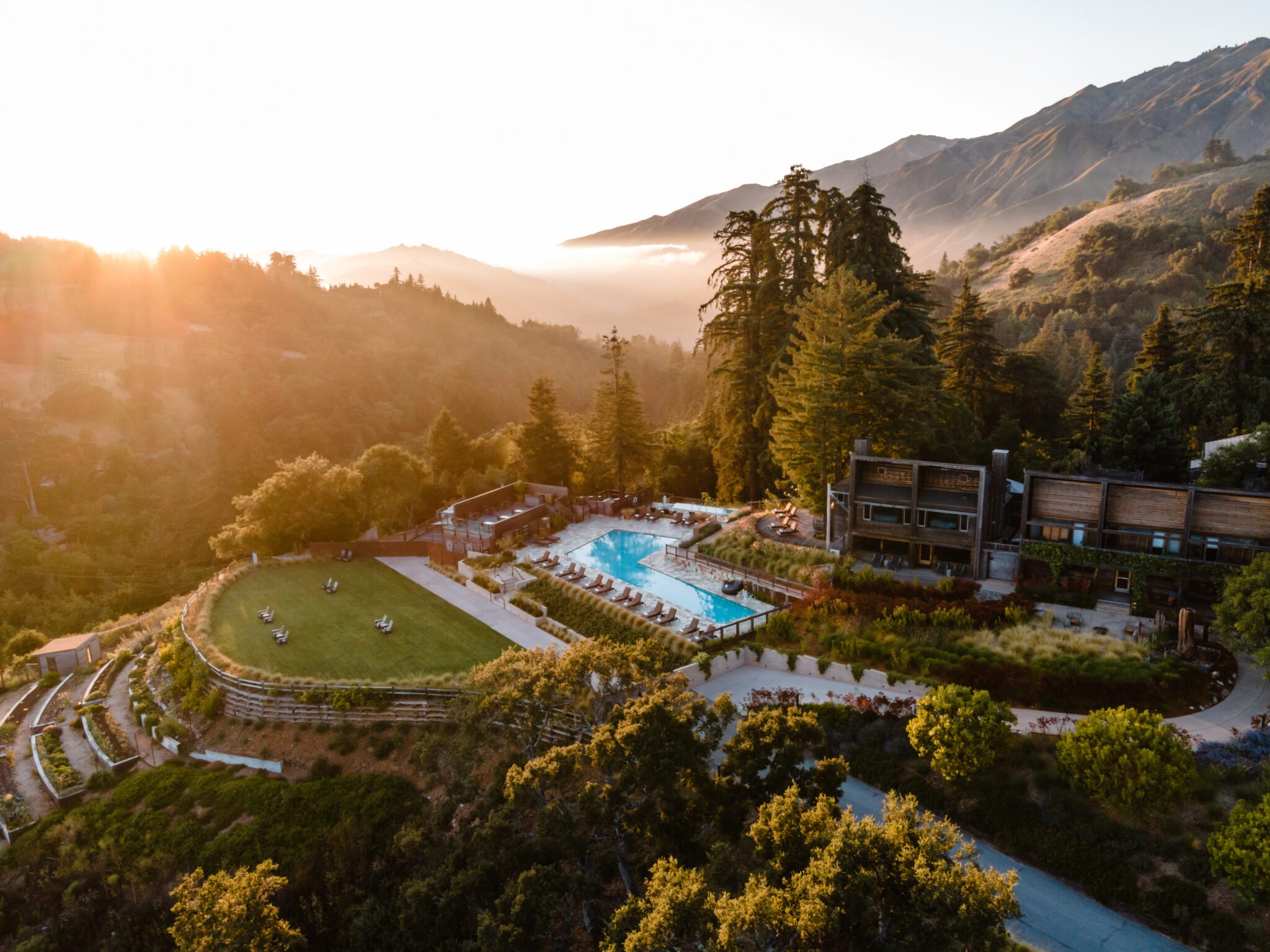
Alila Ventana Big Sur
A hillside sanctuary nestled in 160 acres of redwoods and meadows above the wild Big Sur coast.
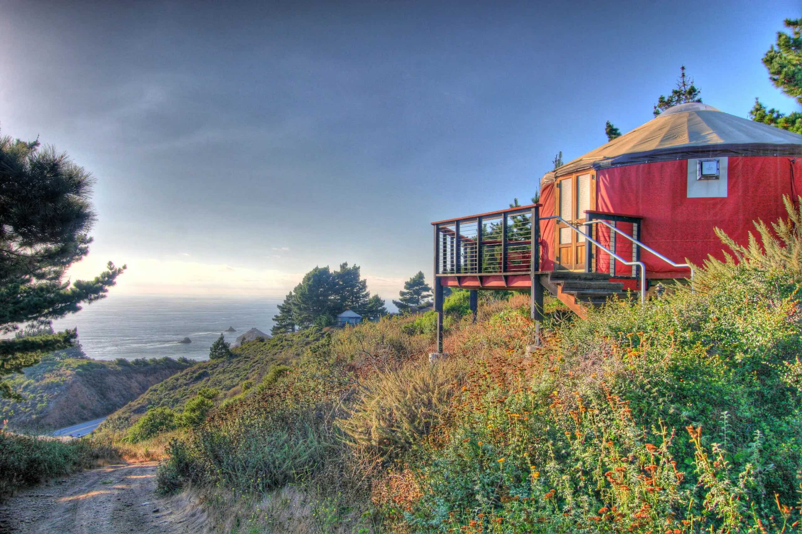
Treebones Resort
Pitched on a panoramic ridge above Gorda, this off-grid glamping retreat features sixteen canvas yurts with private decks framing expansive Pacific views.